We have read a great many articles about the map of Rioja, and they arrive at the same three-colour diagram: Alta in one shade, Alavesa in another, Oriental in a third, with Logroño somewhere near the middle and Haro tucked into a corner. The diagram is not wrong. It is simply not a map of a wine region. It is a map of an administrative decision drawn on top of a river that no one bothers to name. The river is the Ebro, and once you put it back at the centre of the page, the sub-zones stop being colour blocks and start being places.
What follows is not a tour of Rioja. It is a critique of how Rioja is drawn for readers who have never stood on a bridge in Haro and watched the water go past.
What They All Get Wrong About the Rioja Map
The shared error is easy to name once you see it. Almost every online map of Rioja treats the three sub-zones as if they were vertical bands of quality — Alta on top, Alavesa slightly to the side, Oriental somewhere lesser to the east. The colouring is soft, the borders are firm, and the reader is invited to read the map as a hierarchy. Alta reads as prestige. Alavesa reads as elegance. Oriental reads as the part the copy is embarrassed about.
This is not geography. It is marketing rendered as cartography. The three names are administrative subdivisions of a single Denominación de Origen Calificada; they describe zones defined by human decision, not natural difference of rank. When a map colours them like tiers, it teaches the reader to compare rather than to locate. A visitor who then arrives in Logroño and drives twenty minutes north into Alavesa cannot feel the border. There is no border to feel. The river is still the river; the sierra is still the sierra; the vines on either side of the Ebro are answering the same wind.
The second error is nearly universal and follows from the first: the maps omit the Ebro. They will draw the sub-zone boundaries in confident lines and reduce the river to a thin grey squiggle without a label, or leave it off entirely. This is remarkable. The Ebro is the reason there is a wine region here at all. It is the corridor that Tempranillo follows from the western highlands down towards the Mediterranean. It is the axis every anchor town — Haro, Logroño, and, from the northern bank, Laguardia — is oriented against. Removing the river from the map of Rioja is like removing the coast from a map of Bordeaux.
The third error is subtler. Conventional coverage treats the sub-zone names as if they were flavour descriptors, so that a reader is told "Alta gives you this, Alavesa gives you that, Oriental gives you the other." We are a geography desk, not a tasting desk, and we will not extend that habit; but even on its own terms the shorthand collapses. Alta and Alavesa face each other across the Ebro at Haro. They share the same reach of river. They share the same weather coming down off the sierra. To describe them as if they were distant cousins is to write around the map instead of from it.
What Is Almost Always Missing From the Sub-Zone Story
What is missing, in almost every case, is the mountain wall behind Laguardia and the way it changes everything on the ground.
North of the Ebro, running east-west along the top of the Alavesa strip, is a limestone ridge — locally the Sierra de Cantabria, further west the Sierra de Toloño — that acts as a break between the Atlantic weather of the Basque country and the drier, warmer valley on its southern side. Stand in Vitoria on one side of the ridge and in Laguardia on the other and you are in two different climates a short drive apart. The vines are on the sheltered side. The wall is why they can be there. It is also why the Alavesa strip is narrow: it is the flat and gently south-facing bench between a mountain and a river, and it stops where the mountain stops. No online map we have seen draws this ridge with the weight it deserves. Most do not draw it at all.
What is also missing is a sense of the river's direction. The Ebro enters Rioja from the west, from the Basque highlands, and leaves it heading east towards the Mediterranean; the whole region is read downstream. Haro sits high on that gradient, near the confluence where the Río Tirón joins the Ebro. Logroño sits further down. Oriental extends the region eastward, into flatter country where the valley opens out. When the sub-zones are drawn as adjacent colour blocks, this downstream logic is lost, and with it the intuition that a traveller moving from Haro to Alfaro is moving with the water, not across an administrative grid.
What is missing, finally, is the honesty about what Oriental actually is. The old name — Rioja Baja — was retired and replaced with Rioja Oriental for reasons that were part editorial, part cartographic: "baja" read as lower in status, when what the word actually meant was lower on the river. Oriental is the eastern, warmer, lower-elevation portion of the valley. It is not a lesser Rioja; it is a different piece of the same river. The rename was, in effect, an acknowledgement that the map had been misread for decades. That episode is a gift to anyone writing about the region and it is almost never used.
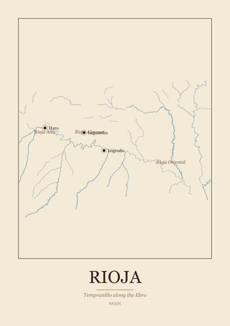 Rioja
The print from this article · from €29.95
View the print →
Rioja
The print from this article · from €29.95
View the print →
What I Would Say Instead: The Ebro as the Region
If we were drawing the map from scratch, we would begin with the river.
We would draw the Ebro thick and label it in the same weight as the town names, because it is the organising fact of the region. We would draw the Sierra de Cantabria — a hard line on the northern side, a mountain wall about as long as the Alavesa strip itself — because without it the northern bench does not make climatic sense. We would draw the anchor towns as three specific decisions rather than as generic dots. Haro at the western end, where the Tirón meets the Ebro and where the town's old station district became one of the most concentrated bodega neighbourhoods in Europe. Logroño roughly at the region's middle, on the south bank, where the Ebro passes through a proper city with bridges old enough to be part of the pilgrim route to Santiago. Laguardia perched on its low hill on the northern side, looking down over the Alavesa vineyards towards the river, with the sierra at its back.
Only after those elements are in place would we draw the sub-zone lines, and we would draw them lightly. Rioja Alta, on the south and west, is the higher, cooler, wetter end of the valley: closer to the western mountains, further from the Mediterranean influence, holding the greatest concentration of the region's oldest bodegas around Haro. Rioja Alavesa, on the north bank between the river and the sierra, is a thin geographical strip that owes its existence to the wall behind it. Rioja Oriental, downstream to the east, is the warmer, more open, more Mediterranean-influenced continuation of the same valley — the part where the river begins to leave the mountains behind.
Read this way, the sub-zones become answers to obvious geographical questions. Why is Alavesa so narrow? Because the shelter runs out where the sierra runs out. Why is Alta the historic hub? Because Haro sits at a confluence and at the transition between highland and valley, and a wine region tends to concentrate its old commerce at exactly such a point. Why is Oriental warmer? Because it is further down the river and further from the mountains that keep the west cool. The three names stop being tiers and start being coordinates.
Tempranillo, then, is not the hero of a marketing story about Rioja; it is the grape that best tolerates the specific bargain the Ebro valley offers between altitude and warmth, between Atlantic memory and Mediterranean tendency. It reads the river the way the towns do. It is grown along the whole length of it, in all three sub-zones, and the interesting question is not which zone "owns" it but how the same grape phrases the same river differently at each point along its course. That question is a geography question, and it is the one the standard three-colour map makes it hardest to ask.
If the reader takes only one thing from this piece, we would like it to be this: when you next open a map of Rioja, find the Ebro first. Trace it from west to east. Note where the sierra shadows the northern bank and where it releases into open country. Place Haro, Logroño, and Laguardia against that axis. The sub-zones will then arrange themselves around the river rather than the other way around, and the region — which drew us to make a print of it in the first place, and which lives in our shop as a river before it lives as a set of names — will finally look like the place it actually is.
 Bordeaux
The print from this article · from €29.95
View the print →
Bordeaux
The print from this article · from €29.95
View the print →



New regions and 10% off your first print.
One email now with your code. No noise after.