Most Old World wine maps mislead you, and they do it on purpose. Hear us out. A wine map that renders appellation borders as tidy coloured polygons is a legal document dressed as geography. The line between Pauillac and Saint-Estèphe in the Médoc is not a river or a ridge; it is a commune boundary drawn for civil administration long before wine law codified it. That is not a criticism, it is a warning. To read the Old World map you have to know which question you brought to it. In this piece we walk three readers past the same four regions — Bordeaux, Burgundy, Champagne, Alentejo — and watch what each of them actually sees.
Before we introduce them, a note on method. Every geographic fact in what follows is drawn from Natural Earth's 1:10 million river and coastline data, which is what we work from at the drawing board. The three readers are composite illustrations, not people we interviewed. We built them because the same map answers different questions for different hands, and the honest way to show that is to walk the same paper past three of them and describe, plainly, what each one is looking for.
Scenario 1: The Cellar-Door Traveller — matching bottles to towns on a paper map before a trip
Picture a reader planning ten days in France in September. She has a rental car booked out of Bordeaux airport, a return flight from Paris, and a spouse who has agreed to the drive on the condition that they see, and not merely drink, the country in between. She has a wine map spread across the kitchen table and a rough route sketched on the back of an envelope. Her question, sitting over the map, is not "which wine is best" but "where do I sleep, and what does the town look like when I get there."
For this reader the Old World map is a road map first and a wine map second, and the drawing that helps her is the one that places the anchor towns clearly. In Bordeaux she is looking for the city itself on the Garonne, and then Saint-Émilion on the right bank and Pauillac up in the Médoc as her two poles. She notices, if the map is honest, that these three points are not near each other in any driving sense. Bordeaux the city sits where the Garonne is joined by the Dordogne to form the Gironde estuary. Pauillac is an hour north up the Médoc peninsula. Saint-Émilion is across the water on the Dordogne side. The map that renders Bordeaux as a single blob of colour is lying to her by omission; the trip is three separate days, not one.
She then moves east and finds Burgundy, and the drawing changes shape entirely. Where Bordeaux was a triangle around an estuary, Burgundy is a line: Dijon at the top, Beaune in the middle, Nuits-Saint-Georges between them. The Saône runs down the eastern edge of the whole thing, and the vineyards sit on the west-facing slopes above it. Once she sees the line she understands why every guide to Burgundy is really a guide to the road that runs down that slope — the Côte de Nuits gives way to the Côte de Beaune and the towns come in order like stations on a railway.
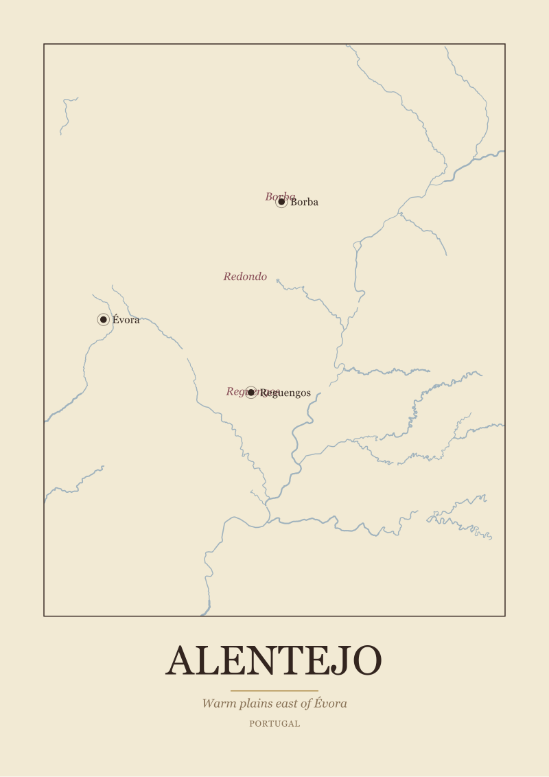
Champagne pulls her further north, and here she is looking for Reims and Épernay with the village of Aÿ between them. The Marne runs west from the region toward Paris, which is a fact she cares about because she is driving from Reims to Paris and did not know until now that the river she was following did the same. Alentejo, if she flew Lisbon instead of Paris, would give her Évora as the anchor city, with Reguengos and Borba as the smaller stops east of it, and the Guadiana river running down toward the Spanish border.
The paper map, for this reader, is a compressed itinerary. She does not need to memorise the appellations; she needs to know which town has the bed and which river she will cross on the way.
Scenario 2: The Restaurant List Reader — decoding an Old World wine list with no sommelier in sight
Now imagine a different reader entirely. He is sitting at a two-top in a restaurant that has a serious European wine list and a waiter who is friendly but not a sommelier. The list is organised by country, then region, then sub-region. There is no glass of water in front of him yet and no mental map to hang the names on. His question, staring at the list, is "where are these places in relation to each other, and does that tell me anything."
For this reader the Old World map is an index of names. He is not going anywhere; he is trying to make one decision in ten minutes, and the geography he wants is relational. When he sees Médoc, Saint-Émilion, Graves and Sauternes on the Bordeaux page he wants to know that the first two sit on opposite banks of an estuary, that Graves runs south of the city on the left bank of the Garonne, and that Sauternes sits further south still where a small tributary called the Ciron meets the Garonne. Whether he then orders any of them is his business. What the map has done is turn four names into four locations he can hold in one hand.
Burgundy on the same list is easier in one sense and harder in another. Easier because the sub-regions on our grounding — Côte de Nuits and Côte de Beaune — are literally north and south of each other along the same slope. Harder because the villages that make up each côte have their own names on the list, and no small map can render them all without turning into a legal chart. The honest studio move, and the one we default to, is to show the two côtes clearly and let the village names sit as text along the slope; the reader who wants Gevrey-Chambertin versus Vosne-Romanée is a reader who already knows where they are.
Champagne on a wine list is where the sub-region matters most, and where the map earns its keep. Montagne de Reims, Vallée de la Marne, Côte des Blancs — three sub-zones, three orientations, three answers to a different question. Montagne de Reims is a horseshoe of chalk hills south of Reims. Vallée de la Marne follows the river west from Épernay. Côte des Blancs is a south-facing slope running south from Épernay. A reader who understands that the three sub-zones are arranged around Épernay like petals around a stem reads the Champagne list differently than one who sees three phrases with no shape.
Alentejo, on this same list, will most often appear with its sub-zones — Borba, Redondo, Reguengos — clustered east of Évora and west of the Guadiana. The reader who has never opened a map of southern Portugal is not being asked to memorise them; he is being asked to notice that they are close together and inland, which is already half the story of a warm-plains wine.
He orders. The bottle arrives. He has not become an expert. He has simply stopped feeling like the list was written in a code he could not read.
 Bordeaux
The print from this article · from €29.95
View the print →
Bordeaux
The print from this article · from €29.95
View the print →
Scenario 3: The Studio Print Buyer — trying to understand what a wine region map is actually drawing
Our third reader is the one who writes to the studio. She has a dining room wall, a partner who cooks, and a growing sense that a framed wine region map would suit the room better than another botanical print. Her question is not about the wine at all. It is about the map itself. When she looks at three different renderings of Burgundy in three different shops, why do they look so different, and which one is telling the truth.
The honest answer is that a wine region map is drawing at least three things at once, and different studios weigh them differently. The first layer is physical geography: rivers, coastlines, contour lines, hills. This is where our own work starts, and where Natural Earth's 1:10 million river and coastline data does the heavy lifting — a public-domain dataset that gives us the same Garonne, Marne, Saône and Guadiana every cartographer draws from. If a map of Bordeaux does not show the Gironde estuary as the meeting of Garonne and Dordogne, it has skipped the most important geographic fact about the region.
The second layer is settlement: which towns are named, which are dots, which are omitted. A print buyer notices this second layer even if she cannot name it. A Champagne map that names Reims and Épernay but not Aÿ has made a choice about density; a map that names every village on the Côte des Blancs has made a different one. Neither is wrong. But she should know that the studio is choosing which names carry the room.
The third layer is administrative: appellation boundaries, sub-zone shading, commune borders. This is where the honesty of the map is most tested. Appellation lines are legal creations. They follow physical geography sometimes, and other times they follow a line drawn by a nineteenth-century clerk. A studio can render them cleanly, or fuzzily, or leave them off entirely and let rivers and slopes do the talking. Our own preference is to draw geography first and let the appellation shapes emerge from it — because the wall is a place for the region, not for the paperwork.
She is not choosing between a right map and a wrong map. She is choosing between a map that leads with rivers and towns and one that leads with legal polygons. Once she can name that choice, the wall becomes an easier decision. If a specific region on that wall is where she wants to start, our own shop draws each of the four regions here at /shop/ in the same geographic register we have been describing.
What All Three Share — the four geographic questions that unlock any Old World region
Read the three scenarios in order and a pattern emerges. Different readers, different questions, but the same four geographic hinges keep doing the work.
The first hinge is the river. Bordeaux is a Garonne region that becomes a Dordogne-and-Garonne region at the estuary. Burgundy is a slope above the Saône. Champagne is a chalk landscape north of the Marne. Alentejo is a warm plain the Guadiana runs through toward Spain. Name the river and you have named the reason the region exists where it does. Water shapes the temperature, the drainage, the historical trade route that made the wine famous enough to travel.
The second hinge is the anchor town. Bordeaux the city, Beaune, Reims and Épernay, Évora. These are the places wine merchants set up in, the places the négociant houses grew from, the places the tourist stays and the restaurant list starts. A region without a legible anchor town is a region no one visits.
The third hinge is the sub-zone. Médoc versus Saint-Émilion. Côte de Nuits versus Côte de Beaune. Montagne de Reims, Vallée de la Marne, Côte des Blancs. Borba, Redondo, Reguengos. Sub-zones are where the region admits it is not one thing. A map that shows the sub-zones in geographic position — not in a legend box — is a map that has done its job.
The fourth hinge is orientation. Which way does the slope face. Which side of the river holds the vineyards. Which direction does the valley run. This is the hinge our print buyer notices last and cares about most; it is also the one the traveller and the list-reader benefit from even when they cannot name it. A slope facing east catches morning sun and dries the dew early. A river valley running east-west channels weather in a way a north-south valley does not. The map that gets orientation right stops being decoration and starts being an argument.
 Burgundy
The print from this article · from €29.95
View the print →
Burgundy
The print from this article · from €29.95
View the print →
Which Scenario Is You — a short diagnostic to pick your entry point into the map
If you are reading this because a trip is on the calendar, you are the traveller, and the map you want prioritises anchor towns and the roads between them. Start with rivers and cities; the appellations will make more sense after you have driven the distances.
If you are reading this because you keep meeting European wine lists and feeling under-equipped, you are the list-reader. Your map is an index. Learn the shape of each region as a rough gesture — Bordeaux as a triangle around an estuary, Burgundy as a slope, Champagne as three sub-zones around Épernay, Alentejo as a plain east of Évora — and the names on the list will find their places on their own.
If you are reading this because a wall in your home is empty and a map has entered your head, you are the print buyer. The question for you is not which region but which register. Ask any map you consider whether it draws rivers before appellations, whether it names the anchor town clearly, and whether it lets the sub-zones sit where they actually sit. If the answer is yes, it is a map that will keep giving you something to look at years after the frame goes up.
The three readers are illustrations, not people. But the four questions are real, and once you know which one you are asking, the Old World map stops being a puzzle and starts being a place.
FAQ
What does "Old World" actually mean on a wine map?
Old World, in the wine sense, refers to the historical wine regions of Europe — the ones whose reputations were made before the vine travelled to the Americas, Australia and South Africa. On a map it is not a single boundary but a family of regions across France, Portugal, Italy, Spain, Germany, Austria and their neighbours. Bordeaux, Burgundy, Champagne and Alentejo, the four we walked through here, are four members of that family and by no means the whole set.
Why do so many wine maps show appellation borders instead of rivers?
Because appellation borders sell certainty. A coloured polygon labelled Pauillac is easier to point at than the actual gravel terraces that make Pauillac what it is. Appellation lines are legal creations, drawn by regulators, sometimes tracking physical geography and sometimes tracking old commune boundaries. They are useful for wine law and shipping paperwork; they are less useful if what you want is to understand why a region tastes of the place it comes from.
How accurate are the rivers on a typical printed wine map?
It depends on the source. Serious studios work from open geographic datasets — Natural Earth's 1:10 million river and coastline data is a common public-domain baseline — which give the same Garonne, Marne, Saône and Guadiana any cartographer would draw. Decorative maps sometimes stylise rivers into ribbons for composition. Neither is wrong, but a map that departs from real river geometry loses the argument that the river shaped the region.
Which of the four regions on this article is easiest to read on a map?
Burgundy, probably. Because the Côte d'Or is essentially a single slope running roughly north-south with Dijon at the top and the Côte de Beaune at the bottom, the whole region resolves into a line on the page. Bordeaux is more demanding because the Gironde estuary splits it into a left bank and a right bank that have to be understood separately. Champagne rewards a reader who knows Épernay is the hub of three sub-zones. Alentejo rewards knowing where Évora sits.
Do the anchor towns in each region actually make the wine?
Not directly, in most cases. The anchor towns are where the merchants, brokers and shipping houses set up, and where the region's commercial identity crystallised. Beaune is the trade heart of Burgundy without being the source of its most famous single vineyards. Reims and Épernay house the great Champagne houses; the grapes come from surrounding villages. Évora anchors Alentejo administratively and culturally more than viticulturally. Anchor town and vineyard location are related but not identical.
Why is the Médoc peninsula treated separately from the rest of Bordeaux?
Because the Médoc is a distinct geographic body: a peninsula of gravel and low relief running north from the city of Bordeaux, hemmed by the Gironde estuary on one side and the Atlantic on the other. Its soils, drainage and exposure differ enough from the right bank around Saint-Émilion — where clay and limestone dominate — that the two halves of Bordeaux have always read as separate regions on the ground, even before appellation law formalised the split.
Are wine region borders the same as country borders?
No, and it is worth stating plainly. Wine regions are defined by administrative and geographic criteria specific to viticulture; they sit inside country borders but rarely respect internal ones. A region like Alentejo covers a large slice of southern Portugal but has no relationship to the country's district boundaries. Reading a wine map as if its lines were political will mislead you. Reading it as geography with a legal overlay is closer to the truth.
What is the single most useful thing a beginner can learn from an Old World map?
That the river came first. Every one of the regions in this article is legible once you name its river and its anchor town. The Garonne and Bordeaux. The Saône and Beaune. The Marne and Épernay. The Guadiana and Évora. Get those two facts for a region and the sub-zones start to fall into orientation around them. Everything else — appellation shapes, village names, producer histories — attaches to that geographic spine.


New regions and 10% off your first print.
One email now with your code. No noise after.