Porto sits on the Douro. That is the wine region every Portugal itinerary treats as the answer, and it is, on its own terms, a good answer. But the country's wine map continues for roughly five hundred kilometres south of it, and most of what continues is a different geography entirely. The Alentejo alone — the warm plains east of Évora, drained by the Guadiana, with anchor towns at Reguengos and Borba — covers close to a third of mainland Portugal. It is not a detour from Porto. It is a separate country of wine, and reading it as a footnote to the Douro is the mistake we want to correct here.
What the Numbers Actually Say (the Portuguese wine map after you leave the Douro)
Pull up a physical map of Portugal and lay a finger on Porto. Now drag that finger south, past the mouth of the Douro, past Coimbra, past Lisbon, down toward the Spanish border in the southeast. You have just travelled the length of the wine country most itineraries pretend does not exist. It ends, on the eastern side, at the Guadiana — a river that rises in central Spain, crosses into Portugal, and traces the country's border with Spain before turning south toward the Gulf of Cádiz. Along its middle course, on the Portuguese side, the land opens into the Alentejo.
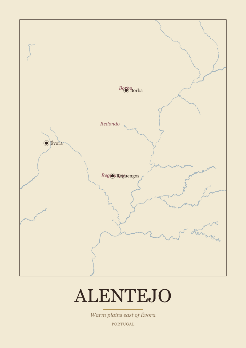
We keep saying "the Alentejo" as if it were one thing. It is not. The name means "beyond the Tejo" — beyond the Tagus, the river that cuts Lisbon in half — and it is a directional term more than a regional one. What sits beyond the Tejo, in wine-country terms, is a broad tableland punctuated by low hills, whitewashed towns, and the slow-moving Guadiana. The Alentejo's wine sub-zones — Borba, Redondo, Reguengos — cluster on the eastern side of that tableland, closer to the border than to the Atlantic. Their anchor town is Évora, which sits inland at roughly the centre of gravity of the region.
The receipt, then, is geographic and unambiguous: Portugal's wine map does not stop at the Douro because Portugal does not stop at the Douro. The country continues for another five hundred kilometres, and the largest single wine region within that continuation — measured by land area — is the one drained by the Guadiana, anchored by Évora, and subdivided into Borba, Redondo, and Reguengos. That is not a rumour. That is the map.
We are being careful with numbers on purpose. Precise hectare counts, exact producer tallies, current vintage output — those figures change year on year and belong in an official yearbook, not in a geography brief. What does not change is the shape of the land. The Guadiana still runs where it ran. Évora still sits where it sits. The three named sub-zones still cluster where they cluster. Those are the facts you can plan a trip around, and they are the facts most "beyond Porto" listicles skip entirely because a listicle format cannot handle the idea that a region is defined by a river rather than by a ranking.
What Nobody Mentions (the Alentejo is a geography, not a detour)
The word "detour" is doing quiet damage to Portuguese wine tourism. Search any English-language planner for what to do south of Porto and you will find the Alentejo filed under "day trips from Lisbon" or "if you have extra time". This is a category error. The Alentejo is not adjacent to a wine region — it is a wine region, and it is larger than several full appellations elsewhere in Europe put together. Filing it as an addendum to Lisbon is like filing Bordeaux as an addendum to Toulouse.
Here is what nobody mentions, and what the grounding forces us to notice: the Alentejo is defined by a river most first-time visitors have never heard of. The Guadiana is not the Douro. It does not carve dramatic terraces into schist. It does not funnel tourist boats through gorges. It moves slowly across a wide, warm plain and, for much of its Portuguese course, forms the border with Spain. The wine sub-zones — Borba, Redondo, Reguengos — sit inland of the river, on the Portuguese side, west of the border. Their character is shaped by that inland position: hot summers, cool nights on the higher ground, and long light. This is a warm-climate wine geography, not a river-terrace one. The two are as different, on the ground, as Champagne is from Priorat.
The second thing nobody mentions is that the sub-zone names themselves are the map. Borba is a town of white marble in the eastern Alentejo, and the sub-zone that carries its name is centred on that town. Redondo is another town, and another sub-zone. Reguengos — properly Reguengos de Monsaraz — is a third town, southeast of Évora, and its sub-zone reaches toward the Guadiana and toward the huge Alqueva reservoir the river now feeds. When we say "the Alentejo has three named sub-zones", we do not mean three abstract administrative divisions. We mean three towns you can drive to, sleep in, and use as bases. The sub-zone is the town's hinterland. That is how the map works.
The third thing nobody mentions is that this treatment — town as anchor, hinterland as sub-zone — is the same logic that organises the great French wine regions in our grounding. Bordeaux is anchored by Bordeaux the city and subdivides into Médoc, Saint-Émilion, Graves, Sauternes. Burgundy is anchored by Beaune and subdivides along the Côte d'Or. Champagne is anchored by Reims and Épernay and subdivides into Montagne de Reims, Vallée de la Marne, Côte des Blancs. The Alentejo is anchored by Évora and subdivides into Borba, Redondo, Reguengos. We are not reaching for the comparison; the structure is genuinely parallel. Reading the Alentejo through that structure — town, hinterland, river — turns a "vast, undifferentiated warm plain" into a legible region with three named entrances.
 Alentejo
The print from this article · from €29.95
View the print →
Alentejo
The print from this article · from €29.95
View the print →
The Real Cost (what it takes, in kilometres and days, to read Portugal past Porto)
Now put a real number on it. Porto to Évora, in a straight line on the map, is a long diagonal across most of Portugal — the kind of distance you do not do as an afternoon side trip. In practical driving terms it is a full day's transit if you also want to eat lunch and stop at anything on the way. Évora to the eastern Alentejo sub-zones — Borba first, then Redondo, then Reguengos looping south — is another day of driving if you take it slowly, and slowly is the only speed that makes sense in country this open.
So the real cost of "Portugal beyond Porto", read through the Alentejo lens, is three days at absolute minimum: one to cross the country, one to reach Évora and settle, one to loop through the three named sub-zones. Four days is more honest. A week starts to do it justice. Anyone who tells you the Alentejo is a Lisbon day trip is selling you a coach tour, not a region.
The other cost, the one nobody puts in kilometres, is the recalibration you have to do when you arrive. If your only Portuguese wine reference is the Douro, the Alentejo will read wrong for the first day. You will look for steep slopes and find plains. You will look for a dramatic river gorge and find a slow border river. You will look for stone-terraced vineyards and find rows on gently rolling ground. Nothing is broken; the reference frame is. The Alentejo is not a smaller Douro or a warmer Douro. It is a different geographic organism entirely — river as border rather than river as axis, plain as substrate rather than slope as substrate, inland town as anchor rather than port city as anchor. Understanding that costs a day of adjusted expectations, and then everything makes sense.
We draw the Alentejo the way we draw every region in the studio: from the Guadiana out, with Évora placed where it actually sits, with Borba and Redondo and Reguengos labelled at their real positions rather than as vague pins in a plain. The maps we ship at see the Alentejo print are built from public-domain geographic data at 1:10 million — the same Natural Earth base that underlies every serious cartographic project — because a region drawn honestly does not need dramatic embellishment. The Guadiana is dramatic enough on its own terms.
The larger cost, if you want the full accounting, is that "beyond Porto" is not one trip. Even bracketing the Alentejo, Portugal has wine geographies further north — around Viseu, around the coast between Porto and Coimbra, in the green northwest between Braga and the Minho river — that each have their own logic and their own anchor towns. We are not going to fake precision on the ones our grounding does not cover. What we can say honestly is that the country is at least three separate wine journeys, that only one of them is the Douro, and that the largest of them by area is the one the Guadiana defines.
If You Only Remember One Thing
Portugal's wine map does not have a centre. It has a river system. The Douro anchors the north. The Guadiana anchors the southeast. Between and around them are geographies with their own anchor towns and their own logic, and treating the Douro as the country's wine identity is a north-facing bias that flattens the rest of the map.
If you are planning a trip past Porto, plan it around the Alentejo first — Évora as base, Borba and Redondo and Reguengos as the three sub-zone entrances, the Guadiana as the eastern edge of the whole thing. That is not a scenic detour. That is a second, southern country of Portuguese wine, and it is the map's honest answer to what "beyond Porto" actually means.
 Douro
The print from this article · from €29.95
View the print →
Douro
The print from this article · from €29.95
View the print →
FAQ
What is the Alentejo, geographically, and why does it matter for wine?
The Alentejo is the broad tableland of southern-central Portugal that sits east of the Tejo (Tagus) river and reaches to the Guadiana, which forms much of the country's border with Spain. Its named wine sub-zones — Borba, Redondo, Reguengos — cluster inland around Évora. It matters because it is Portugal's largest wine geography by area outside the Douro, and it is defined by a river system and a set of anchor towns rather than by a single dramatic valley.
Which town should we use as a base for the Alentejo?
Évora is the natural anchor. It sits roughly at the centre of gravity of the region's named sub-zones, with Borba to the northeast, Redondo directly east, and Reguengos (properly Reguengos de Monsaraz) to the southeast toward the Guadiana. From Évora, each sub-zone is a manageable drive, which means you can read the region by making the town your fixed point and looping outward day by day rather than moving hotels every night.
How is the Alentejo actually different from the Douro?
Different geography entirely. The Douro is a river carving steep terraced slopes through schist; the Alentejo is a warm inland plain drained by the Guadiana, with sub-zones sitting on gently rolling ground around inland towns. The Douro's logic is slope and terrace; the Alentejo's logic is plain and anchor town. Neither is a version of the other. Planning them as if they were similar is the error most itineraries make.
Do we need to cross into Spain to reach the Guadiana side of the Alentejo?
No. The Guadiana forms the border, but the Portuguese wine sub-zones sit inland of the river, on the Portuguese side. Reguengos de Monsaraz is the closest of the three named sub-zones to the Guadiana, and it is fully within Portugal. You can read the whole Alentejo, river and all, without ever needing to cross the border. Bringing your passport is still sensible — the border is right there — but it is not required for the wine geography itself.
How many days should we budget for Portugal beyond Porto if we want to do the Alentejo properly?
Three days is the absolute floor: one for transit, one to reach Évora and settle, one to loop the sub-zones. Four days lets you take Borba, Redondo and Reguengos as separate half-days rather than rushed stops. A full week starts to let you sit still in the country, which is arguably the point of visiting a plain. Anyone marketing the Alentejo as a Lisbon day trip is compressing a region into a coach tour.
Why do most "wine regions of Portugal" articles skip straight to Douro and Vinho Verde?
Two reasons. First, the Douro has dramatic river-gorge scenery and a fortified wine (Port) with a British-market marketing history behind it, which makes it easy to write about. Second, listicle formats reward regions that photograph well and have a one-line elevator pitch, and a plain drained by a slow border river is harder to reduce to a hook. That is a limit of the format, not of the region. Reading the Alentejo through geography rather than through photography restores it to its actual scale.
Is there a way to visit the Alentejo without a car?
It is genuinely harder than in the Douro, where the river itself functions as a transport corridor. The Alentejo is a plain with towns spaced across it, and the honest answer is that a car (or a driver) makes the region legible in a way that public transport does not. Évora is reachable by train from Lisbon, and once you are there you can base for a few days without moving, but visiting Borba, Redondo and Reguengos as separate sub-zones effectively requires road transport.
What can we say honestly about vintages, hectares, or producer counts in the Alentejo?
Not much, and that is the point. Precise hectare figures and producer tallies shift year on year and belong in an official regional yearbook rather than in a geography brief. What does not shift is the shape of the land: the Guadiana still runs where it runs, Évora still anchors the region, and the three named sub-zones — Borba, Redondo, Reguengos — still cluster in the eastern Alentejo. A trip planned around those fixed geographic facts will not be wrong next year the way a trip planned around this year's production figures might be.



New regions and 10% off your first print.
One email now with your code. No noise after.