There is a pattern in the questions we receive about Priorat. Someone reads that the wines come from llicorella — the Catalan word for fractured black slate — and wants to know whether it is the rock that makes the wine, or something else in the slope. The question has sharpened as Priorat's sub-zone geography has moved from producer memory onto bottle labels: village names like Gratallops, Porrera and Poboleda now travel with the wine. What used to live behind the counter of a shop in Falset is now legible on a shelf. That is the change worth reading.
The Rock Everyone Names But Few Actually Describe
Llicorella gets named in almost every English-language paragraph ever written about Priorat, and then the paragraph moves on. So it is worth stopping on the word.
Llicorella is a Catalan noun for a dark, layered metamorphic rock — a slate, in the geological sense, that fractures along planes rather than crumbling into soil. It looks like what it is: sheets of dark grey and near-black stone, sharp-edged where fresh, weathering to a rusty brown skin where the flakes have been sitting in the sun for a season. You can walk a vineyard row in Priorat and see more rock than earth. The plough turns up plates, not clods. Where a hoe would bounce off a Bordeaux gravel bed, in Priorat it clangs.
The important word in that description is *fractured*. Llicorella is not a soil that happens to be rocky; it is a rock that has been shattered vertically by folding and by weathering, so that a vine root can slip down between the plates rather than having to bore through them. This is the geological trick that makes the region agriculturally coherent at all. On paper — steep slopes, near-zero topsoil, low rainfall, killing summer heat — Priorat should not grow anything. What lets it grow vines is that the rock itself is porous in the vertical direction. The vine root does not need soil the way we usually mean soil; it needs a crack, and llicorella is a rock made of cracks.
We are careful not to overclaim on the chemistry. The temptation, when writing about a famous terroir, is to reach for a mineral vocabulary — to say the slate donates this or that flavour to the finished wine. Ampelographers and geologists have argued about that transfer for a century and the honest answer is that the chain from rock to glass runs through the vine, the vintage and the cellar in ways nobody has cleanly isolated. What we can say without hedging is geographic: llicorella is the reason the vines can live where they live. That is a large enough claim.
The Slope Does More Work Than the Soil
If you strip away the vocabulary of terroir and look at Priorat as a landscape, the rock is only half the story. The other half is the angle.
Priorat sits inland of Tarragona, in the folded, broken country south of the Ebro basin, and the vineyards are not planted on plains. They are planted on the sides of hills — often at gradients that require terraces cut by hand, or the older *costers* system where the vines simply follow the fall line and the pickers slide down between them. The slope is what determines whether the vine gets morning sun or afternoon sun, whether the water that falls in a spring storm runs off in ten minutes or soaks the cracks for a week, whether the wind from the coast reaches this fold or dies against the ridge next door.
The rock and the slope are not independent. Llicorella exists because the region was compressed and lifted by the same tectonic movements that made the surrounding sierras — the same forces that gave Priorat its amphitheatre of ridges around the Siurana valley also stood the rock up on end and cracked it. So when a producer says the wine is a llicorella wine, they are implicitly saying it is a slope wine, because the two conditions arrived together. You cannot separate the mineral from the tilt.
The vine root does not need soil the way we usually mean soil; it needs a crack, and llicorella is a rock made of cracks.
This matters for how a reader should look at any Priorat map. The best geographic exercise you can do with the region is to ignore, for a moment, the sub-zone names and the producer names and just trace the contour lines. Where the contours crowd together, the vines are working hard. Where they open out, the vines are on the easier shoulders. Two neighbours with the same rock, the same grape (Garnatxa is the region's calling card) and the same rain in a given year can be doing quite different agricultural things because one is on a 40 per cent gradient facing south-east and the other is on a 15 per cent shoulder facing west. The rock is a constant. The slope is not.
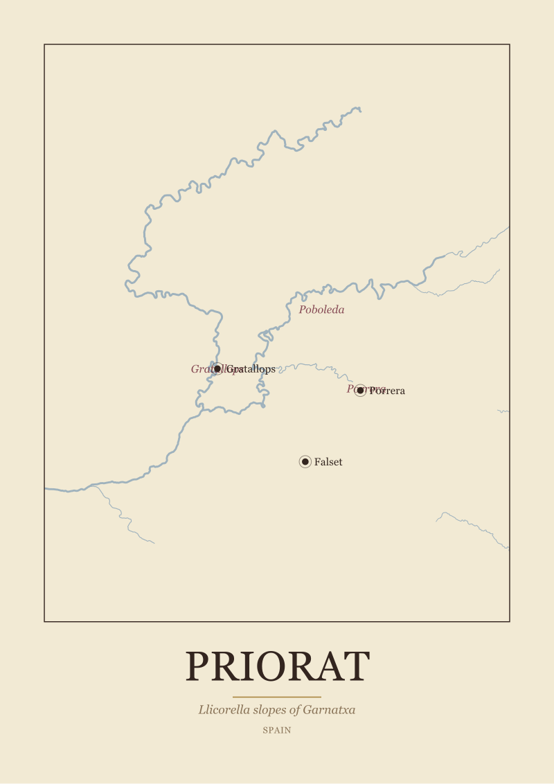 Priorat
The print from this article · from €29.95
View the print →
Priorat
The print from this article · from €29.95
View the print →
The Siurana Is the Line the Region Draws Itself Against
Priorat has a river, and it is worth naming: the Siurana. The Siurana is a modest waterway on any European scale, but it is the geographic spine the whole region reads against. Every sub-zone, every anchor town, every slope of consequence is oriented in relation to this valley and its tributaries.
Falset, the administrative anchor of the wider comarca, sits on the ridge above the river system. Gratallops, Porrera and Poboleda — the three sub-zone villages we will come back to in a moment — each sit in their own fold of the drainage. When you fly over the region, or trace it on a good topographic map, what you see is a hand-shape: the Siurana as the main line, tributaries running in from either side, villages perched on the shoulders between them, vineyards falling away down the sides of every finger. The mountain called Montsant closes the northern rim like a wall; the Serra de Llaberia and the coastal ridges close it to the south.
This is why the border of the region, on a map, looks almost hand-drawn — because it more or less is. The historic Priorat, the small enclosed *prioratus* of the Carthusian priory at Scala Dei from which the region takes its name, is a watershed rather than a political rectangle. The vineyards trace the sides of the valleys that drain into the Siurana. The rock stops at the ridge; the drainage stops at the ridge; the appellation stops at the ridge. It is one of the few appellations in Europe where the legal boundary and the geographic boundary substantially agree, and that is because the geography made the argument first.
There is a practical consequence for anyone trying to understand the wines. When Priorat is discussed as a monolith — as a wall of dark, concentrated Garnatxa — what is being flattened is the fact that the Siurana valley is not one exposure. The tributaries run in different directions. A vineyard on the north side of a tributary faces south; on the south side, it faces north. In a region this hot, that ninety-degree difference is not cosmetic; it is what allows some sites to hold acidity into September when others have already given it up. The river is the axis of the argument.
The Sub-Zone Names Are Geography, Not Marketing
For most of Priorat's modern history, the sub-zones existed as knowledge inside producers' heads and as informal shorthand at the bar in Falset. In the last two decades they have been codified — a set of village-level identifiers that a wine can carry on its label if the fruit and the winemaking meet certain conditions. Gratallops, Porrera and Poboleda are three of the names on that list, and the three that non-specialist readers are most likely to encounter.
The temptation is to read those names the way one reads brand extensions: as marketing sub-divisions of a hot region. The right way to read them is as geography that was already there.
Gratallops sits toward the south-west of the classical Priorat, on shoulders that fall toward the Siurana. It is the village most associated with the region's modern revival — the one whose name appears in the early stories of the small group of winemakers who reset Priorat in the 1980s and 1990s. Its slopes tend to be lower in elevation than the northern reaches and warmer in profile. Porrera sits eastward, in a fold of a tributary system, in a bowl that traps cool air at night. Poboleda sits toward the north, closer to the wall of Montsant, at elevations that shift the whole growing-season equation upward by several degrees at night. Same rock. Different slope orientation, different altitude, different diurnal range.
What the sub-zone names give a careful reader, then, is not a taste badge — it is a coordinate. When a bottle says Porrera on the label, it is saying: this fruit came from a bowl in the eastern folds, at these altitudes, on these exposures. When it says Poboleda, it is saying: from the cooler, higher northern flank. The vocabulary is geographic before it is anything else. And that is the change we have watched over the past decade: the shelf has caught up with the map. What used to be tacit knowledge inside the region is now printed on the glass, in front of the buyer, in a place where a reasonably curious person can decode it with a topographic map and half an hour.
That is a small piece of infrastructure and it is worth noticing. It means the reader has been handed the tools to disagree with generalisations about Priorat — including generalisations we have made in the first three sections of this article. Once the names are on the labels, the wines can be compared like with like, village to village, and the flat description of Priorat as "the llicorella region" starts to acquire the shading it always had underneath.
 Bordeaux
The print from this article · from €29.95
View the print →
Bordeaux
The print from this article · from €29.95
View the print →
So What Do You Actually Do
If you want to read Priorat properly, stop treating llicorella as an answer. It is a starting condition. It is the reason the region is agriculturally possible. It is not the reason two neighbouring vineyards, on the same broken slate, in the same year, produce wines that are recognisably different from each other. That difference is geometry — slope, aspect, elevation, and the way a particular fold of the Siurana valley catches its afternoon light.
The most useful habit is to reach for a topographic map of the region before you reach for a tasting note. Find the Siurana on it. Find Falset on the ridge; find Gratallops on its shoulder toward the south-west; find Porrera in its eastern bowl; find Poboleda closer to the northern wall of Montsant. Trace the contour lines around each village. Notice which slopes face south and which face north. Notice which folds are open to the coastal wind and which are shielded. Once the region is a shape in your head rather than a word, the sub-zone names on any label you meet stop being mysterious and start being coordinates.
The second habit follows from the first. When Priorat is described in the flattened language of a single terroir — the dark slate, the old Garnatxa, the concentrated wine — hold that description against the geography. It is true at the altitude of a whole region. It is not true at the altitude of a single valley fold. The sub-zone system is the region telling you, plainly, that it does not want to be read as a monolith any more. That is worth listening to. If you want to hold this geography in front of you as an object rather than a paragraph, our studio draws the region — the Siurana, the villages, the sierras — as a wine map print, from public-domain hydrography, at the resolution the sub-zone conversation actually requires.



New regions and 10% off your first print.
One email now with your code. No noise after.