We layered a dozen Priorat maps against Natural Earth's 1:10m river dataset. Most of them are wrong in the same place. The Siurana bends where they show it straight, and the llicorella slopes above Gratallops vanish when the cartographer opts for a flat political outline. What follows is a decision tree for reading any Priorat map that lands on the desk. Three questions, asked in order. Each answer changes what the map is actually saying — whether it shows the geography that made the region famous, or just the administrative shell drawn around it.
Question 1: Does the Map Show the Siurana River?
The Siurana is the reason Priorat exists as a wine region rather than another patch of inland Catalonia. It cuts down from the Serra de Montsant, threads past Cornudella, and then loops through the schist amphitheatre that holds Gratallops, Porrera and Poboleda before eventually meeting the Ebro. A map that omits it is telling you the region is a name. A map that draws it is telling you the region is a shape carved by water. This question comes first because everything downstream — where the slopes fall, where the villages sit, why the sub-zones cluster the way they do — is answered by that river.
If Yes
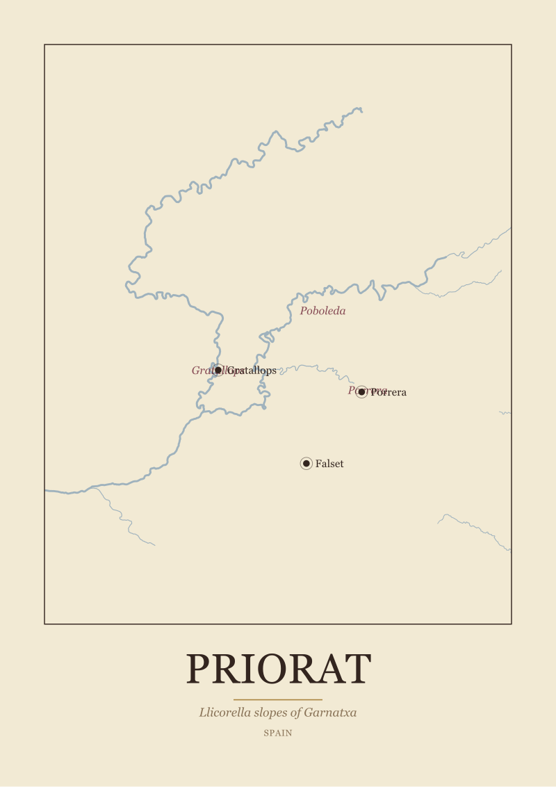
Look at how the river is drawn. On our Natural Earth reference, the Siurana is not a straight blue line; it is a serpentine with tight meanders where it enters the Priorat basin from the northwest. A serious map will render at least the major bends between Cornudella de Montsant and the confluence area near Falset. If the cartographer has taken the trouble to draw the tributaries — the small drainages that fall off the Montsant escarpment into the Siurana — you are looking at a map made by someone who understood that Priorat's terraces are essentially small watersheds facing each other across the river. That is the reading you want. The river anchors Falset to the south-east and pulls Gratallops, the ridge village, up onto its northern flank.
If No
You are almost certainly holding an appellation map — a political outline of the DOQ Priorat boundary, colour-filled, with village dots dropped on top. These are useful for one thing: proving a bottle is inside the denominación. They are useless for understanding why the wine tastes of the place it comes from. If the map replaces the river with a straight administrative border, treat the villages as floating labels rather than as points on a geography. The map is not lying; it is answering a different question. File it as a legal document, not as a landscape.
Question 2: Are the Llicorella Slopes Rendered, or Just the Outline?
Llicorella is the black, broken slate that gives Priorat its identity — the surface that Garnatxa vines root into, sometimes drilling several metres down through the fissures to find water. The slopes are not gentle; they are the reason harvest is done by hand and by mule, and the reason yields are famously small. A Priorat map that does not attempt to render relief is giving you a country without its topography. Since llicorella is the single most-cited fact about the region in every serious wine reference, a map that leaves it out is choosing decoration over geography.
If Yes
The rendering can take three forms, in ascending order of usefulness. First: shaded hillshading, generated from a digital elevation model, that makes the amphitheatre around Gratallops visible as a bowl of ridges. Second: contour lines at reasonable intervals — 50 or 100 metres — so a reader can count the drop from the ridgetops down to the Siurana. Third, and rarest: a texture or hatch that specifically distinguishes llicorella from the surrounding limestone and calcareous soils of the outer Montsant. That third layer requires geological data, not just topographic data, and few consumer maps bother. When you find one, keep it. It is the map that answers the question of why a vineyard four hundred metres apart from another vineyard produces a different wine.
If No
A flat, coloured polygon labelled "Priorat" tells you nothing about why the region is famous. If you want to test this quickly, cover the labels and ask whether the shape alone communicates altitude, slope, or aspect. In almost every case, it does not. This is the map you find on the back of tourist brochures and inside the front cover of general wine atlases. It has a job, and the job is orientation. It is not, and does not pretend to be, a reading of the terroir. The absence of relief is the absence of the argument.
 Priorat
The print from this article · from €29.95
View the print →
Priorat
The print from this article · from €29.95
View the print →
Question 3: Are Gratallops, Porrera and Poboleda Marked as Distinct Places?
Priorat is not homogeneous. The DOQ recognises a set of sub-zones — vi de vila designations tied to specific villages — and the three that carry most of the region's historical weight are Gratallops, Porrera and Poboleda. They sit on different sides of the amphitheatre, at different altitudes, on slopes that face different directions. A map that treats them as interchangeable dots on a coloured field is treating a mountain region like a supermarket aisle. A map that draws them as distinct settlements, ideally with their surrounding vineyard bands, respects what the region actually is.
If Yes
Look for two things. First: are the villages placed correctly relative to the river and to each other? Gratallops sits on a ridge above the Siurana. Porrera is tucked into a side valley to the east. Poboleda lies further north, closer to the Montsant escarpment. If the geometry between them looks right, the cartographer has consulted a real base map. Second: are the surrounding vineyard areas — even loosely sketched — distinguishable? Some studio maps hatch or tint the vineyard bands around each village, which is the closest a two-dimensional print can come to showing that these are three different rooms in the same house. Falset, the administrative anchor town to the south, will usually appear as a larger dot; that is correct, and it does not mean Falset is a sub-zone in the same sense.
If No
A single-colour DOQ blob with only "Priorat" written across it is the map equivalent of writing "France" on a bottle of Burgundy. It is true and it is empty. When the interior is not drawn, the sub-zones are not readable, and the map has quietly decided that the difference between Gratallops and Poboleda does not matter to its audience. Sometimes that is a defensible editorial choice — a map made for someone who has never heard of Priorat needs to communicate one idea, not five. But once you know the sub-zones exist, a map that hides them starts to feel evasive.
If You Answered Everything: The Recap Table
Three questions, two answers each, eight combinations. The recommendation column below is a studio judgement: what the map is genuinely good for, given what it does and does not show.
| Q1: Siurana drawn? | Q2: Llicorella / relief? | Q3: Villages distinct? | Recommendation |
|---|---|---|---|
| Yes | Yes | Yes | A cartographer's map — read it slowly and keep it on the wall. |
| Yes | Yes | No | Strong geography, weak on human settlement — good for terrain, thin on culture. |
| Yes | No | Yes | River and villages are honest — the missing slopes leave the wine unexplained. |
| Yes | No | No | An orientation map with a real river — useful for planning, not for reading terroir. |
| No | Yes | Yes | Odd but interesting — the geology reads without the water that shaped it. |
| No | Yes | No | Decorative relief — pretty, but the region loses both its river and its rooms. |
| No | No | Yes | A village index — treat it as a directory, not as a landscape. |
| No | No | No | A legal outline of the DOQ — file it as an administrative document. |
A quick note on how to use the table. If the map you are holding lands in the top row, you have a working reference — the kind of print a studio would draw and a wine buyer would frame. If it lands in the bottom row, do not assume the map is bad; assume it was made for a different question. Most of the maps we tested against the Natural Earth base line sat in the middle rows: honest about one or two of the three, silent on the third. The exercise is not to grade the map. It is to know what you are actually looking at before you cite it.
 Burgundy
The print from this article · from €29.95
View the print →
Burgundy
The print from this article · from €29.95
View the print →
What This Piece Did Not Cover
Three things, deliberately. This piece did not address the specific geology of llicorella — the difference between the Palaeozoic slate that dominates the classical vineyards and the surrounding calcareous soils of the outer Montsant DO. That is a geological argument, and it belongs in a geological piece; we handled it here as a surface phenomenon a map can render, not as a rock we can describe. Second, we did not cover the vi de vila and vi de finca classification framework in any procedural detail — how a specific vineyard is elevated, who decides, what the paperwork looks like. That is an appellation-law question, and it is a separate argument from how a cartographer chooses to draw a sub-zone on a map. Third, we did not name individual producers, and we will not; the studio's rule is that producers appear as historical or geographic fact and never as a shopping list. If you want a Priorat map drawn from the same base data we used to test the others, one lives in the shop — the Siurana in its correct meanders, the amphitheatre in relief, the three villages where they belong.
FAQ
Why is the Siurana river the single most important feature on a Priorat map?
Because the region's shape is a river shape. The Siurana cuts an amphitheatre out of the schist between the Serra de Montsant and the lower hills to the south, and the classical villages — Gratallops, Porrera, Poboleda — are all positioned on slopes that fall toward that river. Remove the Siurana from the map and you lose the argument for why the vineyards sit where they sit. A political outline can survive without the river; a geographic reading cannot.
What does llicorella actually mean, and can a map show it?
Llicorella is the local Catalan name for the broken black slate that covers the classical Priorat slopes. It is a soil formed from Palaeozoic schist, cracked into small angular fragments, and it is the surface into which Garnatxa vines drive their roots. A two-dimensional map cannot show the soil directly, but it can show its consequence: the steep, dissected relief that only that kind of rock produces. Hillshading, contour lines and geological hatch patterns are the three ways cartographers approximate it.
Are Gratallops, Porrera and Poboleda the only Priorat sub-zones worth mapping?
No. The DOQ recognises a broader set of village-level designations, and Falset, La Morera de Montsant, Bellmunt and others each have their own character. We singled out Gratallops, Porrera and Poboleda because they carry most of the region's historical and cartographic weight and because they sit on three distinct sides of the amphitheatre. A more complete studio map would include the others; a decision-tree reading tool focuses on the three that most reliably reveal whether the cartographer respected the interior.
Why does the piece treat the appellation outline as a "legal document" rather than a map?
Because a DOQ boundary answers a legal question — is this vineyard inside the denominación or outside it — and nothing more. It is a line drawn by regulators, not by geography. Rivers cross it, slopes cross it, roads cross it, and the line does not respond to any of them. Treated as legal information, it is precise and useful. Treated as a reading of the landscape, it is silent on almost everything that makes Priorat worth reading in the first place.
What is the difference between Priorat and the surrounding Montsant DO on a map?
Priorat (DOQ) is the inner region built on llicorella slate; Montsant (DO) is the ring of vineyards around it, largely on calcareous and limestone-influenced soils, with the Serra de Montsant escarpment forming a shared northern backdrop. A geographic map will show the two as one continuous landscape divided by a rock change, not by a wall. An administrative map will show them as two separate coloured polygons with a hard border between them. Both are true; they answer different questions.
Does the direction a slope faces matter enough to appear on a Priorat map?
Yes, and it is one of the harder things to render honestly. Slope aspect — whether a vineyard faces east, south or west — changes ripening dramatically in a region where altitudes run from roughly one hundred to more than seven hundred metres and where summer heat is real. A hillshade generated from a digital elevation model captures aspect implicitly; contour lines suggest it; a flat polygon erases it. When a map lets you see which side of the Siurana amphitheatre a village sits on, it has already told you something meaningful about the wine.
Should a good Priorat map show the Serra de Montsant escarpment behind the region?
Almost always, yes. The Montsant range is the northern wall of the amphitheatre; it shelters the region from cold northern air and defines the upper limit of most of the classical vineyard land. A map that crops tightly to the DOQ boundary loses that context and makes Priorat look like an isolated patch. A map that extends the frame to include the escarpment restores the reading — the region is a bowl below a wall, not a floating shape on a blank field.



New regions and 10% off your first print.
One email now with your code. No noise after.